
Recognising air masses
Now you’ve completed the quiz in the previous Step, take a look at the table below which summarises what is happening to the air from the four major air masses as they approach the UK.
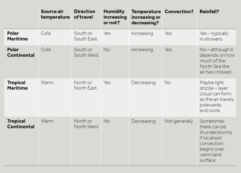
You can view a PDF version of the recognising air masses table above.
The satellite image in Figure 1, shows Tropical Continental air over much of continental Europe and the UK. Although there is a front coming in from the west, before it arrives much of the UK is cloud free and sunny. However, it’s worth noting those small, puffy blobs of cloud over the centre of Spain and France. In small areas, the sun has warmed the ground enough to make the air there rise and form localised summer thunderstorms.
Figure 1: A satellite image showing Tropical Continental air over much of the UK and continental Europe.© Copyright EUMETSAT/Met Office
Figure 2: A satellite image showing Polar Continental air over the UK and North Sea © Copyright EUMETSAT/Met Office
Figure 3: A satellite image showing Polar Maritime air over much of the North Atlantic and Europe © Copyright EUMETSAT/Met Office
Figure 4: A satellite image showing Tropical Maritime air © Copyright EUMETSAT/Met Office
The characteristics of the air mass may change between summer and winter. For example, in the summer, even easterly winds from central Europe or the Ukraine could be counted as tropical continental, as the continent becomes so hot at this time of year. Also in the summer, the low cloud formed by Tropical Maritime air can be evaporated by the Sun during the day, clearing the sky but leaving the air warm and humid. With a polar maritime air mass, in summer, the difference between west and east is not as important – as the ground warms, local convection can trigger showers anywhere. We rarely experience Arctic air in the summer.
Take a look at the beautiful image of current surface air flow on earth.nullschool.net. Using this image for guidance, can you see where you are based on the map? What direction is the air currently coming from in your area? What might that mean for the weather?
Share your thoughts in the discussion below. Remember you can ‘Like’ and respond to comments made by other learners, and don’t forget you to include #FLrainorshine in any discussions you may have about the course on Twitter, Facebook or Instagram.
Come Rain or Shine: Understanding the Weather


Come Rain or Shine: Understanding the Weather
Reach your personal and professional goals
Unlock access to hundreds of expert online courses and degrees from top universities and educators to gain accredited qualifications and professional CV-building certificates.
Join over 18 million learners to launch, switch or build upon your career, all at your own pace, across a wide range of topic areas.


