
Pakistan floods 2010
In the next few articles and activities, we will explore the build up to and impact of the floods in Pakistan in 2010 in order to consider the relationship between the environment, hazards and those who live there.
Southwestern Asia, India and Bangladesh receive summer monsoonal rain. Nearby Pakistan normally receives less intense, more intermittent summer rains, usually confined to the northeastern regions. Pakistan tends to be characterised by dry weather and even water shortages during the annual cycle.
However, in 2010 rainfall was abnormally high across Pakistan, resulting in widespread flooding through the Indus River catchment. 2010 was a La Niña year, a period when air pressure and ocean circulation shifts, increasing the temperature of surface water in oceans, increasing the moisture in the air and the rainfall. But even for a La Niña period, the rainfall was unprecedented.
Rainfall and flooding commenced in July and continued until September. In areas where the topography was steep, the ground was dry and deforestation had reduced the absorptive capacity of the ground, rivers rose rapidly in upland areas. Gaurav et al. (2011) identified that the flood water volumes were so great that they breached flood assets, river embankments and river-fed canals, or exceeded the design capacity of flood assets at numerous points along the rivers.
 Map of Pakistan showing extent of flood water and affected districts. (Flood map ©Jesse Allen and Robert Simmon, NASA Earth Observatory, using data from UNOSAT). Click to expand.
Flooding in low-lying southerly provinces lasted for 6 months.
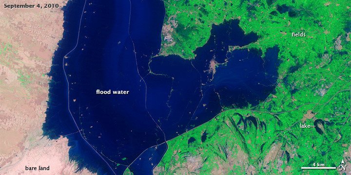 September 2010 (© NASA). Click to expand.
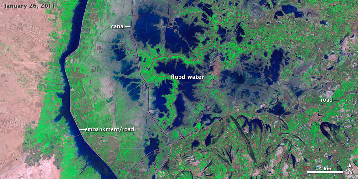 January 2011 (© NASA). Click to expand.
Your task
Is the monsoon a ‘hazard’ in the countries affected by it?To what extent do you feel risks could be predetermined?Post your thoughts on these questions in the comments.
Further reading
Scott, M. (2011) Heavy Rains and Dry Lands Don’t Mix: Reflections on the 2010 Pakistan Flood. NASA Earth Observatory [online] available from https://earthobservatory.nasa.gov/features/PakistanFloods [8 April 2020]
Petley, D. (2010) The floods in Pakistan. 1 August. available from https://blogs.agu.org/landslideblog/2010/08/01/the-floods-in-pakistan/ [8 April 2020]
Petley, D. (2010) Pakistan floods – the progression of the flood wave down the Indus River. 2 August. available from https://blogs.agu.org/landslideblog/2010/08/02/pakistan-floods-the-progression-of-the-flood-wave-down-the-indus-river/ [8 April 2020]
Ali, A. (2013) Indus Basin Floods: Mechanisms, Impacts, and Management [online] available from https://www.adb.org/publications/indus-basin-floods-mechanisms-impacts-and-management [8 April 2020]
References
Gaurav, K., Sinha, R., and Panda, P. K. (2010) ‘The Indus flood of 2010 in Pakistan: a perspective analysis using remote sensing data’. Natural Hazards 59, 1815
Humanitarian Action, Response and Relief


Reach your personal and professional goals
Unlock access to hundreds of expert online courses and degrees from top universities and educators to gain accredited qualifications and professional CV-building certificates.
Join over 18 million learners to launch, switch or build upon your career, all at your own pace, across a wide range of topic areas.


