Skip main navigation

New offer! Get 30% off one whole year of Unlimited learning. Subscribe for just £249.99 £174.99. New subscribers only. T&Cs apply

Find out more

Site visibility

In this article you will learn about the factors that determine site visibility.

The visibility of a site – the way in which it appears on an image – will affect the way in which it is interpreted, and the site understood. Image interpretation is the process of using our knowledge to make decisions about what features we can see in an image, and what these might mean. There are two main factors that determine this. Let us learn about these now.

Image properties

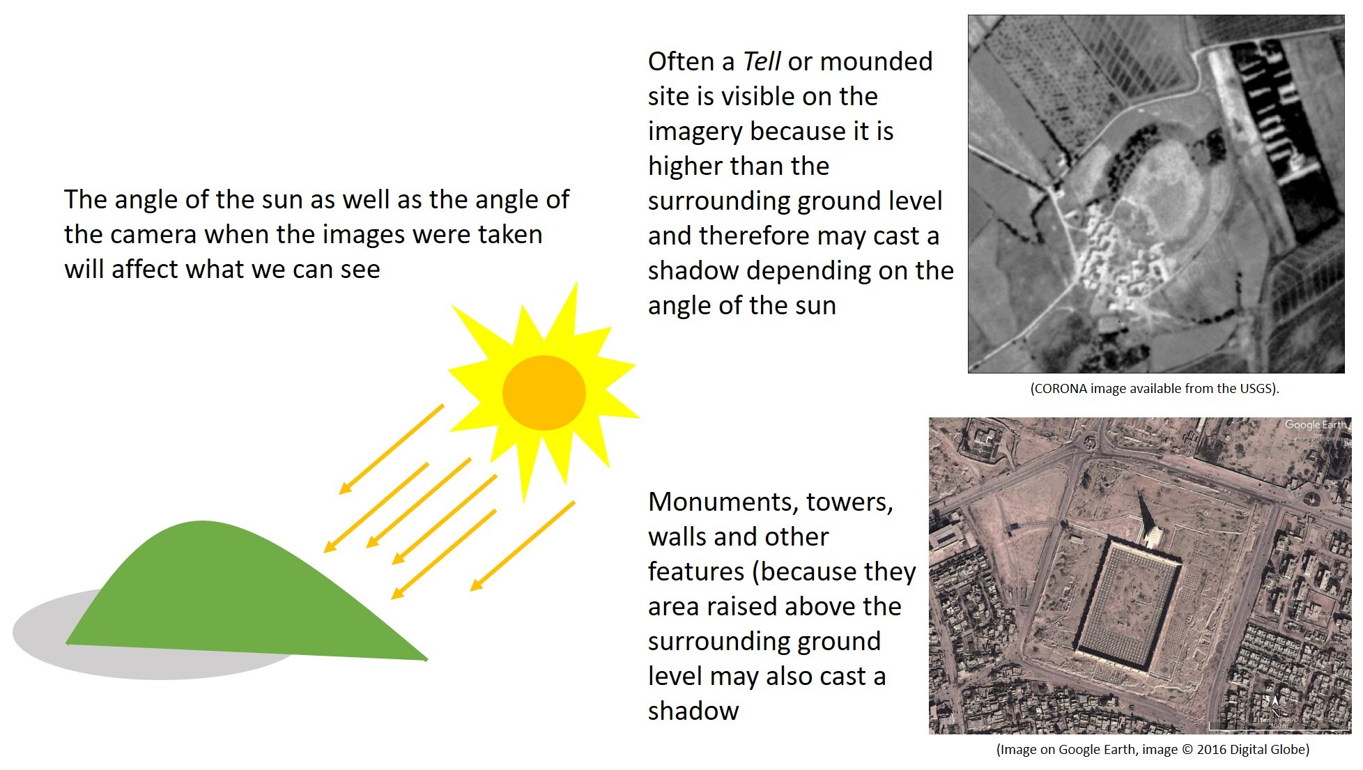
Satellite images are “rasters”, made up of a continuous grid of cells (or “pixels”), each with a value. There is a second course coming soon that will explore the technical details of image properties in more depth. For now though, you need to know that the type and quality of an image affects what we can see in it (Fig 1). Last week we noted that the angle at which the image was taken (vertical or oblique) and the position of the sun (and therefore shadows) shape the properties of the image (Fig 2).

Two images of the same site are presented side by side. The left image is crisp and clear, with good resolution and high contrast between objects. The right image has more faded colour and less definition.
Fig 1: The Early Bronze Age cemetery of Halban, Oman in two different Google Earth images. Note that the same sites appear more clearly in the picture on the left; quality of image influences interpretation. Images © 2021 Maxar Technologies. (Click to expand)

A diagram shows the sun at an oblique angle to a hill, with rays of light represented as arrows, causing the hill to cast a shadow on the side opposite the sun. The accompanying text reads "the angle of the sun as well as the angle of the camera when the images were taken will affect what we can see". In the top right, a satellite image shows a tell casting a shadow to the north-east, with the text "often a tell or mounded site is visible on the imagery because it is higher than the surrounding ground level and therefore may cast a shadow depending on the angle of the sun". In the bottom right, a rectilinear archaeological compound casts a shadow with its walls, and a tower at one end casts a particularly long shadow. The text reads "monuments, towers, walls, and other features may also cast a shadow because they are raised above the surrounding ground level".
Fig 2: The angle of sun’s rays and the resulting shadow determine image quality. (Click to expand)

Environmental properties

Environmental factors affect the visibility of archaeological sites. Key factors include:

Soils, geology and geomorphology

Soils and local geology has a part to play in what we see in an image. The tone/hue of a feature will vary according to soil moisture – drier soils are lighter in hue. This can make some archaeological features more visible (Fig 3).​ Textures are also significant; some “rubbly” surfaces can be difficult to interpret (Fig 4). ​Some scholars have tried to identify soils with an “archaeological signature”, generally as a way of automating their detection. However, there is still a lot of work to be done before this can be applied as a standard method.

A diagram shows a hypothetical soil cross-section with a stick figure standing at the surface. Under the surface, a large ditch has been filled with soil different from the natural soil, represented by a different colour. Next to this is a satellite photo of a ploughed out archaeological site with no plant cover. The soil where the site was is significantly lighter than the surrounding soil.
Fig 3: Differences in soil colour can make some archaeological features more prominent. (Click to expand)

A satellite image shows a hilltop with no clear archaeological sites. On close inspection a trained eye might make out several stone foundations, but they are very unclear because they are the same material and colour as their surroundings.
Fig 4: The iron age village near Rustaq, Oman is difficult to spot in the Google Earth image due to the rubbly local geology. Image ©2021 Maxar Technologies. (Click to expand)

Seasonality and vegetation cover​

Landscapes change over the year. We can see this in differences in vegetation, and in the amount of water in the soil (soil moisture) (Fig 5). ​Vegetation can obscure or highlight archaeological sites, for example along the coastal zone of North Africa (Fig 6). Sometimes we can see cropmarks, caused by crops growing at different rates due to the underlying archaeology (Fig 7). Some archaeological features become easier to see at certain times of the year (Fig 8).

Anjar in Lebanon seen in May on the left, with lush green grass covering the site, and in September on the right after the hot summer has parched the grass, leaving the site plan more exposed and visible.
Fig 5: Seasonal differences apparent at Anjar, a UNESCO World Heritage Site in Lebanon as seen on Google Earth. Image ©2021 CNET/Airbus)

A satellite image from Cyrene, Libya, shows that much of the site is obscured by tree cover, which makes remote or aerial assessments more difficult.
Fig 6: Obscuring trees around Cyrene, Libya as seen on Google Earth. Image © 2017 DigitalGlobe

On the left a cross-section diagram shows a cluster of stones beneath the surface of the ground. Plants grow across the ground, and where there are stones underneath the plants are shorter. Text below the diagram reads "better drainage over stony surfaces" and text above it reads "crops do not grow as well. On the right of the image, the cross-section shows a filled-in v-shaped ditch under the surface; plants grow taller above this ditch than either side of it. Text beneath the diagram reads "soil moisture is greater" and text above reads "crops grow for longer".
Fig 7: Cropmarks arising from vegetation

Side by side satellite images show semi-submerged sites at Lake Hamrin, Iraq, in different seasonal conditions. On the left, the water level is lower leaving more of the land and sites uncovered, but on the right the level is higher covering more of the surface.
Fig 8: The visibility, appearance and surface area of semi-submerged sites in Lake Hamrin, Iraq varies significantly between summer and winter (Sentinel-2 imagery courtesy of the ESA). (Click to expand)

Land cover​

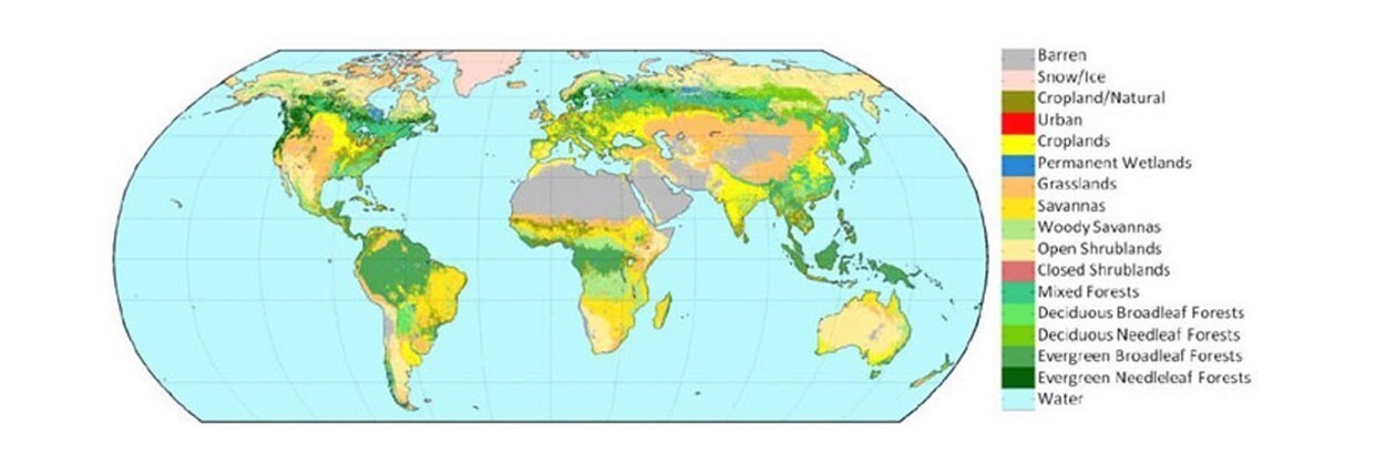
The nature of the land cover (e.g. forest, wetlands) affects the kinds of features that we can see (Fig 9)​. The related term “land use” refers to the way in which humans use a particular area of land​. Both of these affect the preservation, visibility and ease of interpretation of archaeological sites.

A world map of land cover classification, with categories such as barren, urban, croplands, grasslands, etc.
Fig 9: USGS land cover classification. (Click to expand)

Cloud cover​

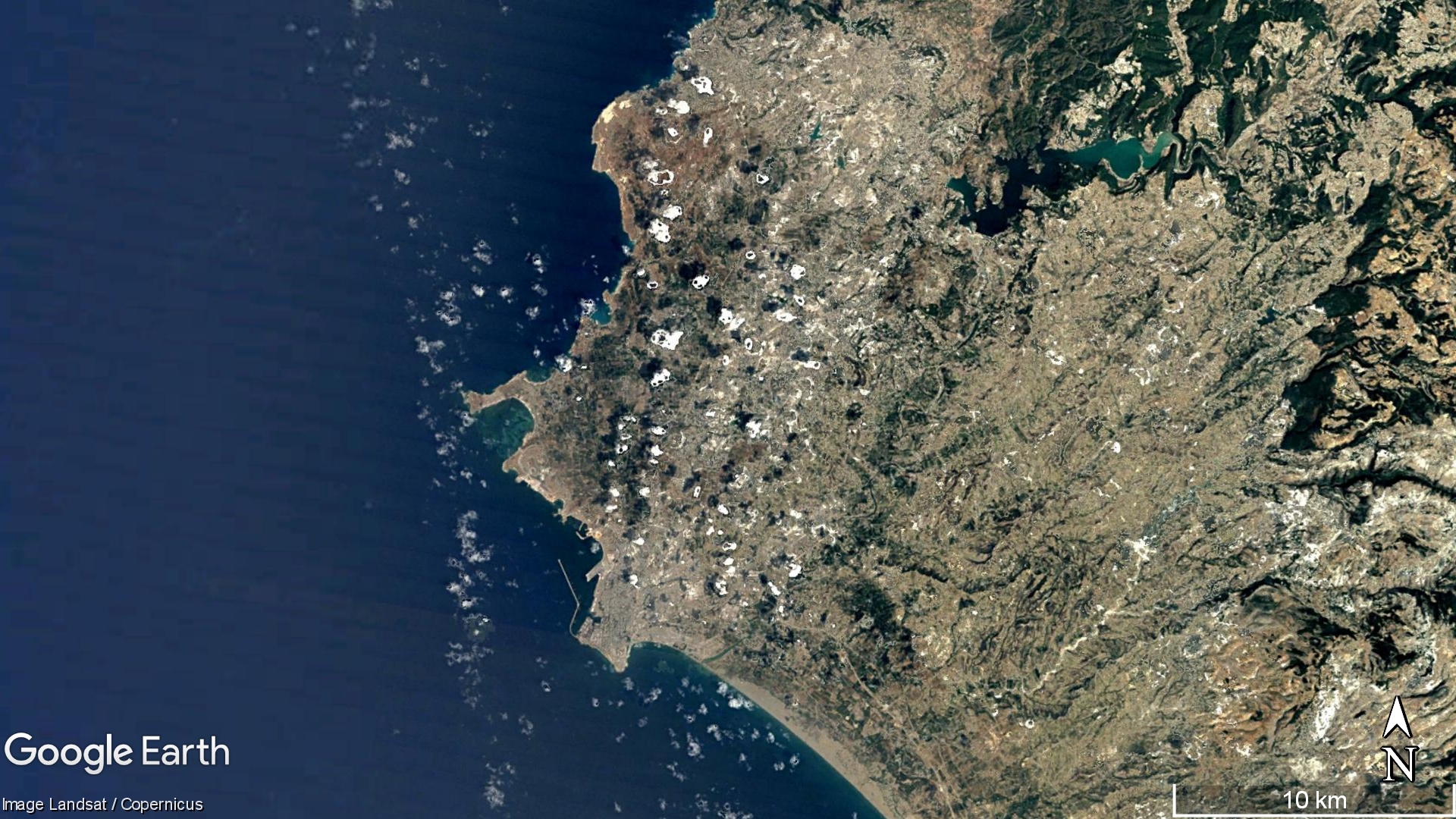
Most satellite sensors cannot penetrate (basically, see through) clouds. If there are a lot of clouds in an image, it might mean that we cannot see the land surface clearly. Partial cloud cover may obscure parts of the land surface; complete cloud cover makes it impossible to see anything at all! Clouds can appear anywhere, but the extent to which cloud cover is likely to be a problem depends on the region of the world in which you are interested and the time of the year when your images were taken (Fig 10).

Small clouds obscuring isolated areas of a coastal region seen in a satellite image.
Fig 10: Clouds can obscure features on the ground as seen on this image on Google Earth. In mountains or coastal locations, this is more common. Image © Landsat/Copernicus. (Click to expand)

This article is from the free online

Endangered Archaeology: Using Remote Sensing to Protect Cultural Heritage

Created by
FutureLearn - Learning For Life

Reach your personal and professional goals

Unlock access to hundreds of expert online courses and degrees from top universities and educators to gain accredited qualifications and professional CV-building certificates.

Join over 18 million learners to launch, switch or build upon your career, all at your own pace, across a wide range of topic areas.

Start Learning now