Gauteng City Region territories and urbanisation processes
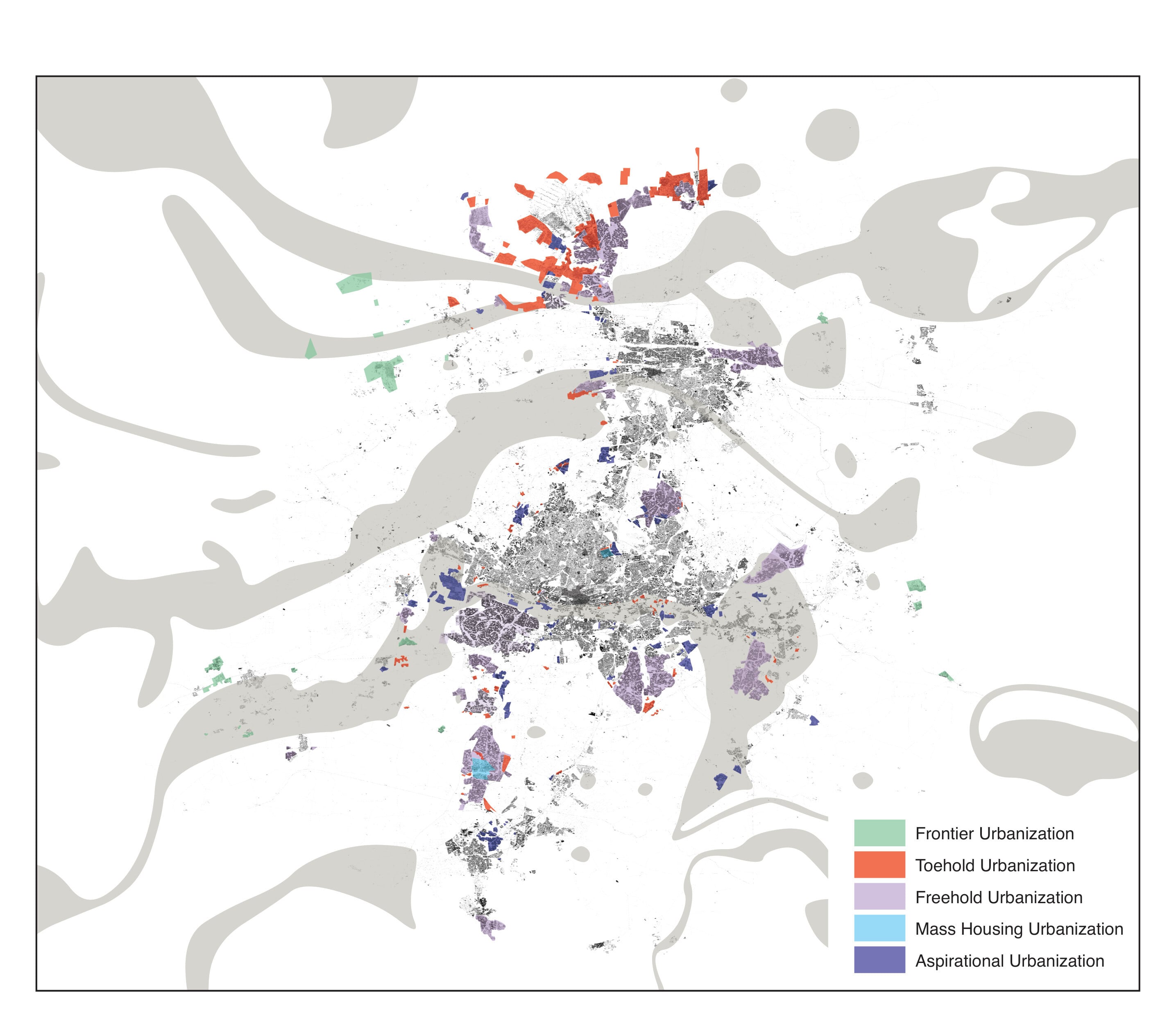
In her work on everyday mobilities, Lindsay Howe develops an analysis of some urbanisation processes shaping the Gauteng City Region.
Read the following extract in which she offers a definition of “toehold urbanisation”.
Extract from: Toehold Urbanisation
Toehold urbanisation is about access: people simply “getting a foot in the door” to opportunities in the GCR. It is typically characterised by a dense morphology of structures, like shacks, erected by members of civil society; because it is implemented opportunistically, it also typically corresponds to precarious living conditions and land tenure. A “toehold” launches people into the urban fabric, utilising complex forms of reliance on transport and social capital. It is originated on small plots of government-owned as well as private land, but the overarching commonality is a lack of legal tenure beyond general eviction law. It occurs near urban centralities and areas of economic opportunity—from Johannesburg’s downtown, to former apartheid buffer zones like its mining belt and industrial parks, even golf courses—because these “valuable” spaces are accessible for people who primarily move on foot.
Historically, toehold urbanisation arose to serve the mining-industrial complex of Johannesburg, evident when tracing the origins of some of the areas reflecting this dense, self-organised shack morphology (Platzky and Walker 1985:335). Areas marked “SSS” for shacks were already inscribed along the edges of the 1950 apartheid diagram for Johannesburg (see Figure 4), reflecting their consistent status of operation beyond the “gaze of the state” (Kihato 2013), while simultaneously being sanctioned by it (Mears 2011). Kliptown, founded in 1903, was the earliest toehold resulting from this process that remains present today (Judin et al. 2014; Kornienko 2016). A proliferation of toeholds emerged once the infamous “pass laws” restricting residential locations for non-white populations were abolished in 1986: in the south, Orange Farm in 1989 and Finetown in the early 1990s (Leong 2009); in the north, Diepsloot in 1991 (Harber 2011) and Kya Sands likely in the early 1990s (Weakley 2013:115); in the east, Ramaphosa in 1994 (Dube 2010:7); and a proliferation of infill settlements along the industrial belt south of the Johannesburg CBD beginning in 1999 (Bennett and Toffa 2014). Most of these settlements were deliberately planned invasions of state and private land, including a subcategory of toeholds: appropriated highrise residential towers in places like Hillbrow or houses in Yeoville (Benit-Gbaffou 2014:252–268).
Until approximately 2008, “informal” settlement was one of the most significant forces restructuring the urban region (Huchzermeyer et al. 2014). Now, there is little urbanisation on greenfield sites; non-sanctioned land invasions are scarce. Toehold urbanisation instead arises on a small scale, corresponding to the development of new centralities, areas of concentrated mining and industry, or adjacent to other developments in logistically accessible parts of the urban region. Individuals can sometimes successfully overcome peripheralisation through access and interpersonal networks—a form of resilience operationalised at various scales as people rework their living conditions (Coe and Jordhus-Lier 2010). However, toeholds as areas often lack the resources to collectively overcome their marginalisation.
You can read the full article here: Howe, Lindsay Blair. 2022. Processes of Peripheralisation: Toehold and Aspirational Urbanisation in the GCR. Antipode 54, 6 pp. 1803–1828. doi: 10.1111/anti.12844
Global Urban Theory Lab: Extended and Displaced Urbanisation


Global Urban Theory Lab: Extended and Displaced Urbanisation