
Wind-driven circulation: from the Ekman spiral to the gyres
Geostrophic balance explained the currents that follow sea-level slopes. But what sets those slopes up in the first place, and what drives the ocean where the surface is nearly flat? The answer, more often than not, is the wind. This reading follows the wind’s influence from the very surface of the sea down to the circulation of whole ocean basins – and along the way explains some of the richest fishing grounds on Earth.
Wind stress: the wind’s grip on the sea
The wind does not simply blow over the ocean; it grips it. That grip is called wind stress – the force per unit area with which the moving air drags the water along, transmitting momentum from atmosphere to ocean.
There is a nice feedback in how this works. As the wind blows harder, it raises larger waves; the rougher surface gives the wind more to push against, so it transmits its momentum even more efficiently. You have more grip on sandpaper than on glass. Because of this double effect, wind stress grows roughly with the square of the wind speed – so a wind twice as strong pushes about four times as hard.
The mixed layer
The first thing the wind’s stress does is stir. Near the surface, wind-driven turbulence blends the water into a mixed layer – a slab of ocean with nearly uniform temperature and properties, from a few tens of metres deep in the tropics to a few hundred at high latitudes.
The mixed layer breathes with the seasons: in winter, strong winds stir it deeper; in summer, sunshine warms and thins it, leaving a strongly layered ocean below. This matters far beyond physics. Phytoplankton live in this layer, and its depth sets the balance between the light they need near the surface and the nutrients that come from below – so the mixed layer is where most of the ocean’s biological production begins.
The Ekman spiral
Now for one of the most surprising results in ocean physics. You might expect wind-driven water to flow in the direction of the wind. It does not.
Over a century ago, the explorer Nansen noticed that Arctic sea ice drifted not with the wind but at an angle to the right of it. The oceanographer Ekman explained why: a balance between the wind’s push, the friction between water layers, and the Coriolis force. The result is that the surface water moves at 45° to the right of the wind (in the northern hemisphere; to the left in the southern). Deeper down, each layer is dragged by the one above and turned further by Coriolis, so the current slowly rotates and weakens with depth – tracing out the Ekman spiral.
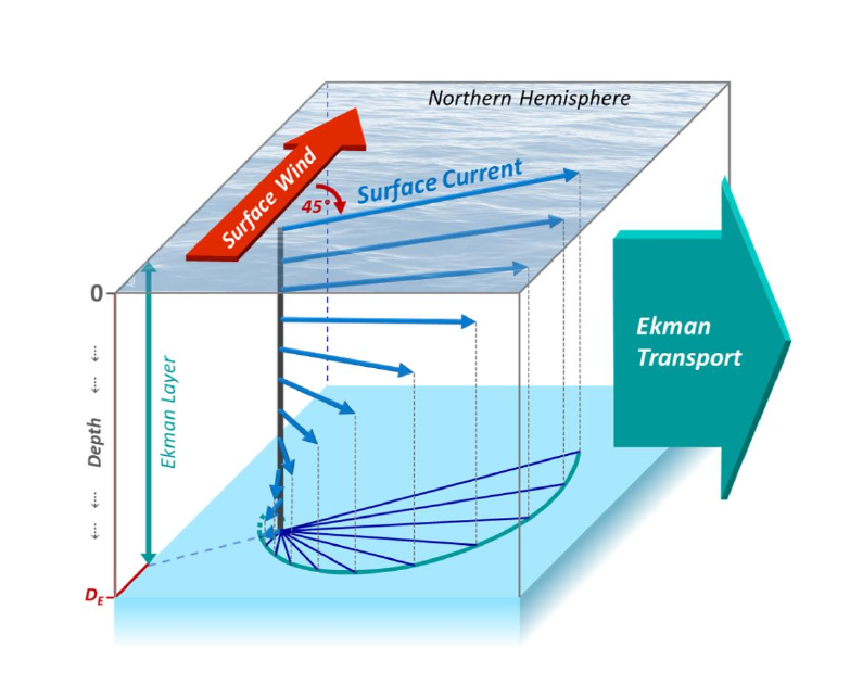 Figure 1: Wind-driven surface water flows at 45° to the wind, and the current rotates and weakens with depth, forming the Ekman spiral. Integrated over the layer, the net Ekman transport is perpendicular to the wind.
Add up the whole spiral, and something clean emerges: the net Ekman transport – the total movement of water in the wind-driven layer – is at right angles to the wind. To the right of the wind in the northern hemisphere, to the left in the southern. Hold on to that fact; it explains a great deal.
Upwelling: the wind that feeds the sea
Because Ekman transport moves water sideways, it can move water away from a place – and something must replace it. That something is deep water, rising from below. This is upwelling, and it is one of the most important consequences of wind in the whole ocean.
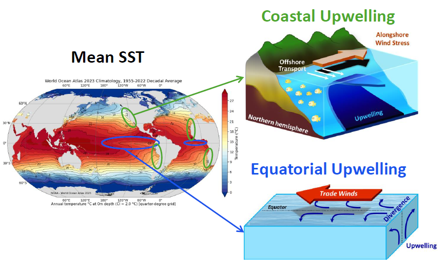 Figure 2: When winds drive surface water offshore (coastal upwelling) or away from the equator (equatorial upwelling), cool, nutrient-rich deep water rises to replace it.
Along a coast, when the wind blows parallel to the shore so that Ekman transport pushes surface water offshore, cold, nutrient-rich water wells up at the coast to take its place. At the equator, the Coriolis force changes sign from one hemisphere to the other, so the trade winds push surface water away on both sides, and deep water rises up the middle.
These upwelling zones are the ocean’s gardens. The four great Eastern Boundary Upwelling Systems – off California, off Morocco, Mauritania and Senegal (the Canary Current), off Peru and Chile (the Humboldt Current), and off Angola, Namibia and South Africa (the Benguela Current) – cover just 1% of the ocean surface but supply around 20% of the world’s fish catch. Two of these four lie along African coasts, which is why wind-driven upwelling is so central to the region’s fisheries.
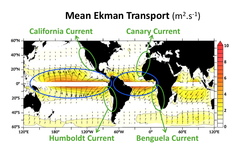 Figure 3: Mean Ekman transport, with the four major Eastern Boundary Upwelling Systems – including the Canary and Benguela currents along African coasts. Divergence of Ekman transport at the coasts and the equator drives upwelling.
You can even see the footprint of all this on a map of sea surface temperature: cold tongues along the equator, and cooler water on the eastern edges of the ocean basins.
Ekman pumping: upwelling in the open ocean
Upwelling is not confined to coasts and the equator. In the open ocean, where the wind’s strength or direction varies from place to place, Ekman transports can spread apart or crowd together. Where they spread apart, water is drawn up from below; where they crowd together, water is pushed down.
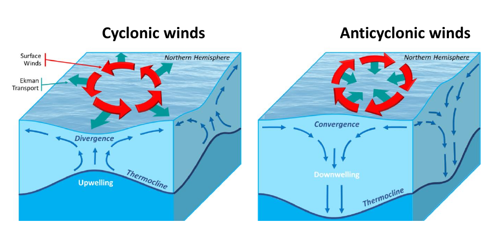 Figure 4: Where winds spin cyclonically, Ekman transports diverge and draw water upward (upwelling); where they spin anticyclonically, transports converge and push water downward (downwelling).
This is Ekman pumping. Cyclonic (anticlockwise) wind patterns pull water up and lower the sea surface; anticyclonic patterns push water down and raise it. And here the two halves of this week’s story meet: by raising and lowering the sea surface, Ekman pumping creates the very sea-level slopes that drive geostrophic currents. The wind, in other words, drives geostrophic flow indirectly.
How the wind builds the gyres
Follow that idea to its conclusion. Across the subtropics, the winds shift from easterly trades near the equator to westerlies further poleward. This large-scale pattern of wind pushes water together in the subtropics, piling it into a broad sea-level high – and around that high, geostrophic balance sets up a great circulating gyre.
This is the origin of the subtropical gyres: the wind, acting through Ekman pumping and geostrophy, drives them. The theory that first showed this – that the pattern (or “curl”) of the wind drives the ocean’s large-scale transport – was worked out by Sverdrup, and later refined by Stommel, who explained a striking feature: the currents on the western side of each gyre are far stronger and narrower than those on the east. That western intensification is why the Gulf Stream, the Kuroshio, and their kin are such powerful, concentrated currents. Each gyre carries tens of millions of cubic metres of water per second – roughly a thousand times the flow of the Amazon.
Key takeaways
- Wind stress transmits the wind’s momentum to the ocean, growing with the square of wind speed, and stirs the surface mixed layer where most biological production occurs
- Wind-driven water flows at an angle to the wind (the Ekman spiral), and the net Ekman transport is at right angles to the wind – right in the north, left in the south
- Where Ekman transport carries surface water away, deep water rises: upwelling along coasts and the equator feeds the great Eastern Boundary Upwelling Systems, two of which lie along African coasts
- Ekman pumping lifts or lowers water in the open ocean, creating the sea-level slopes that drive geostrophic currents
- Through these mechanisms the wind ultimately drives the subtropical gyres and their intense western boundary currents like the Gulf Stream







