
Guided reading: satellites and in-situ observations
This short guided reading builds on the video by looking more closely at the two families of ocean observation – satellite and in-situ – and what each contributes. As you read, pause at the interpretation questions and try to answer them before moving on; they’re there to help you check your understanding, not to be submitted.
Satellite and in-situ observations
Operational forecasting systems rely heavily on both satellite and in-situ ocean observations.
Satellite observations provide:
- large spatial coverage,
- frequent updates,
- and near-global monitoring capability.
In-situ observations provide:
- direct measurements within the ocean,
- vertical profiles,
- and long-term monitoring records.
Both observation types are complementary and essential for operational forecasting.
Satellite systems commonly provide sea surface temperature (SST), sea surface salinity (SSS), sea level, ocean colour, surface winds, and sea ice information. These products are widely used in operational forecasting, marine safety, climate monitoring, fisheries applications, and coastal environmental monitoring.
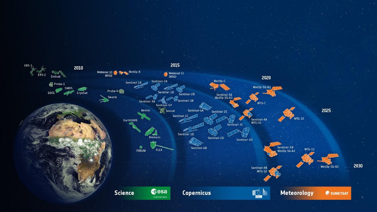
Figure 1. Two decades of European Earth-observation missions — ESA science satellites, Copernicus Sentinels and EUMETSAT meteorological satellites — arranged from 2010 to 2030..
Guided interpretation questions
- Which ocean variables are commonly measured from satellites?
- Why are satellites useful for large-scale monitoring?
- What limitations may affect satellite observations?
- Why are satellite observations important for operational forecasting?
Interpretation example: Satellite observations provide broad and consistent spatial coverage across large ocean regions. However, many satellite products primarily observe surface conditions and may be affected by cloud cover or sensor limitations.
Argo floats and profiling observations
Argo floats are one of the most important global in-situ observing systems used in operational oceanography.
Argo profiling floats commonly measure temperature, salinity, and pressure from the surface to approximately 2000 metres depth. These observations support ocean monitoring, climate studies, forecast validation, and data assimilation systems.
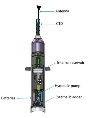
Figure 2. Cutaway of an Argo float, showing the antenna, CTD sensor, batteries, and the hydraulic pump and bladder system that lets the float sink and rise through the ocean.
Guided interpretation questions
- Why are vertical ocean profiles important?
- Which variables are measured by Argo floats?
- What information can Argo provide that satellites cannot?
- Why are subsurface observations important for forecasting systems?
Interpretation example: Unlike satellites, which mostly observe surface conditions, Argo floats provide information about the subsurface structure of the ocean. This is especially important for understanding stratification, mixed layers, and ocean heat storage.
The takeaway
Satellite and in-situ observations are not competitors but partners: satellites give you the broad, repeated, near-global view of the surface, while in-situ platforms like Argo give you the depth and detail that satellites cannot reach. A reliable forecast needs both – and in regions where in-situ networks are sparse, knowing how to draw on satellite and open-access data becomes especially valuable.







